Translated by Google Translator.
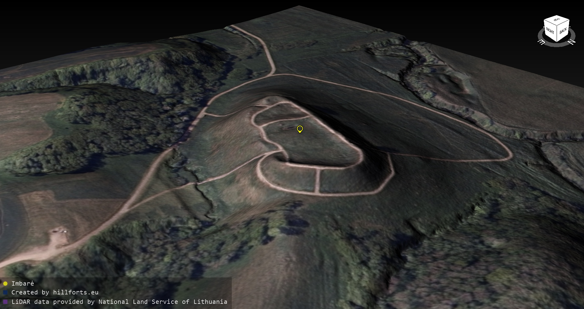
Measurements taken using the planlaufTerrain app. During the measurements, the length, width, height, length of the plain and width of the plain were recorded. Each measurement is recorded on the screen. More than 800 3D models created.
The measurement data is currently available as a file in the open data repository, as well as in the Google map.
360-degree video panoramas of 3D models of Lithuanian hillforts are available on the YouTube channel.
The creation and digital measurement of 3D models of the Iron Age hillforts of Latvia and Estonia have already been done before.
Measurements taken using the planlaufTerrain app. During the measurements, the length, width, height, length of the plain and width of the plain were recorded. Each measurement is recorded on the screen.
The measurement data is currently available as a file in the open data repository, as well as in the Google map.
360-degree video panoramas of 3D models of Lithuanian hillforts are available on the YouTube channel.
Images of 3D models of Lithuanian hillforts are also added to hilforts descriptions in the Lithuanian version of Wikipedia.
The creation and digital measurement of 3D models of the Iron Age hillforts of Latvia and Estonia have already been done before.
3D model data is structured in folders:
- PlanlaufTerrain – a 3D model of the hillfort that can be opened using the planlaufTerrain app.
- PlanlaufTerrain_mobile – 3D model of the hill, openable via the free planlaufTerrain mobile app.
- Sketchfab – files used to import a 3D model to sketchfab.com
- ThreeJs – two compressed HTML files that can be opened with a standard Internet browser, containing a rotatable 3D model with and without orthophoto overlay. Rendering the model is done using the ThreeJs library.
We remind you that currently collected information is available on the websites www.latvijas-pilskalni.lv, hillforts.eu and www.senvietas.lv. The open data repository is available on the website opendata.hillforts.eu. An interactive map of ancient sites has been created, where you will find information related to ancient sites also in our neighboring countries.
Open data can be used freely and free of charge, and used under the Creative Commons Attribution-ShareAlike 4.0 International License.
The open data citizen science project “Latvijas pilskalni” is a private initiative and works thanks to donations. The project won the annual award of the Latvian Open Technologies Association (LATA) in the private sector. and Dzirkaļu hillfort award from Juris Urtāns.